About All Tours Snorkeling ToursFull Day ToursWest ToursFrom Bali ToursPrivate ToursBoat ToursManta Ray Tours Directions Hours & Fees
Find Tours 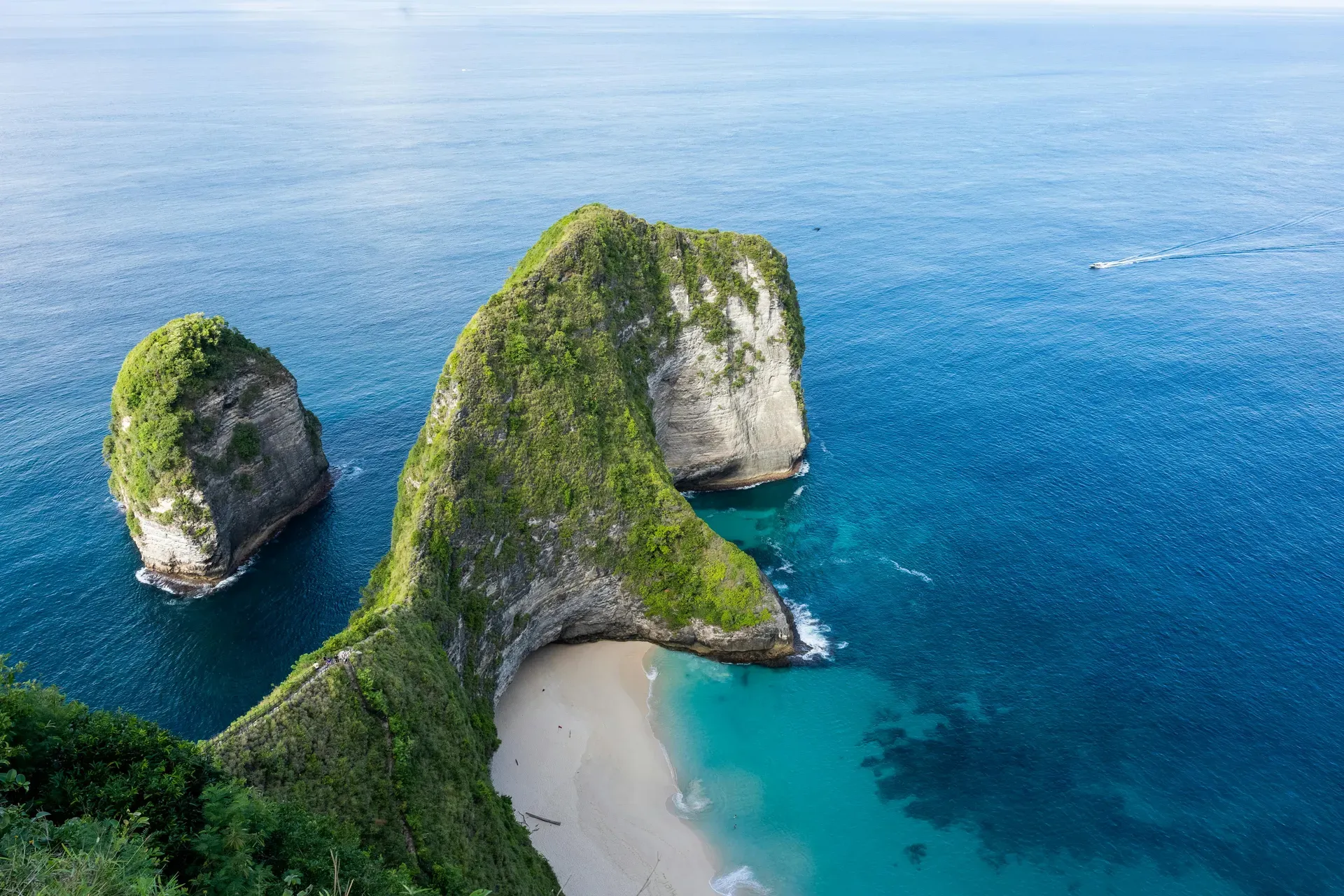
Nusa Penida is a 202-square-kilometer limestone island located across the Badung Strait from mainland Bali. It functions as a critical marine sanctuary for reef manta rays and the oceanic sunfish.
Nusa Penida rises from the Badung Strait as a 202-square-kilometer block of rugged limestone. The island sits 25 kilometers southeast of mainland Bali but operates in a completely different climate zone. Rain falls far less frequently here. The arid landscape supports scrub brush and drought-resistant trees instead of the terraced rice paddies found across the strait. Visitors arriving at Sanur Port board fast boats that complete the 25-kilometer crossing in 45 minutes, stepping off onto the white sands of Toya Pakeh or Sampalan. The public Roro ferry from Padang Bai offers the only method for transporting vehicles across the strait. This journey takes up to 90 minutes and costs IDR 31,700, though departures at 10:00 and 14:00 face frequent delays.
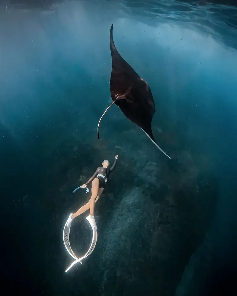
Limestone cliffs dominate the southern coastline, dropping 100 to 200 meters straight into the Indian Ocean. The water below crashes against the rock with enough force to send salt spray high into the air. Marine life thrives in these turbulent currents. A 20,057-hectare Marine Protected Area surrounds the island, creating a reliable habitat for resident reef manta rays and the elusive Mola Mola. Divers enter the water at Manta Point year-round, though heavy swells frequently force boat captains to cancel trips from November to March. Snorkelers must pay a daily retribution fee of IDR 100,000 to enter these protected waters. April to October offer sunny weather, calm seas, and the best visibility for underwater exploration.
Infrastructure remains basic despite a surge in international arrivals. Narrow, unpaved roads connect the 41 villages scattered across the hilly interior. Visitors navigating the island face steep inclines, loose gravel, and deep potholes. Scooter accidents account for the majority of tourist injuries treated at RSUD Gema Santi, the island's only small hospital. Hiring a local driver in a private car prevents most of these incidents. Wheelchair access is non-existent across the island's rugged terrain. Elderly visitors face significant challenges, as most viewpoints require walking on steep inclines in high heat. Families with older children can navigate the sites, but constant supervision is mandatory due to the lack of safety railings on high cliffs. Bring enough Indonesian Rupiah to cover transport, meals, and emergency expenses before leaving the mainland.
Records of human settlement on Nusa Penida date back to 914 AD. The Belanjong Pillar, a stone artifact found in Sanur, details a military campaign by King Sri Kesari Warmadewa that targeted the island. Power shifted centuries later. The Gelgel Dynasty conquered the territory in the 17th century, eventually folding it into the Klungkung Kingdom. The island remained largely isolated from the political maneuvering that shaped mainland Bali during this era. The Klungkung Kingdom utilized the treacherous currents of the Badung Strait as a natural prison wall. Escaping the island by swimming was impossible.
Dutch colonial maps from the early 1900s label the territory as "Bandieten Eiland," or Bandit Island. Mainland Balinese kings used the isolated, dry terrain as a penal colony. Criminals, political dissidents, and practitioners of black magic faced exile here. The harsh conditions and lack of fresh water made survival difficult, cementing the island's reputation as a place of dark magic and punishment. Prisoners built small farming communities, relying on seasonal rains to grow cassava and corn in the thin, rocky soil.
Seaweed farming transformed the local economy in the 1980s. Families living on the northern coral plateaus cultivated Eucheuma cottonii, harvesting the algae at low tide to sell to international cosmetics companies. Farmers tied small fragments of seaweed to nylon ropes stretched across the ocean floor. The harvest cycle took 45 days. The shallow, sunlit waters provided optimal growing conditions. Wooden racks covered the beaches, and the smell of drying seaweed permeated the coastal villages. The industry provided a stable income until warming waters and shifting ocean currents decimated the crops in the 2010s, forcing locals to seek alternative livelihoods.
Tourism replaced agriculture as the primary economic driver shortly after. Social media popularized the T-Rex-shaped headland at Kelingking Beach, drawing thousands of daily day-trippers from Bali. The rapid influx of visitors strained the island's limited resources. Local authorities implemented a mandatory IDR 25,000 entry fee and a strict ban on single-use plastics to manage the environmental impact. Visitors must bring reusable water bottles, as vendors face fines for selling water in bottles under one liter. The government continues to pave the main arterial roads, though the sheer volume of daily boat arrivals—often exceeding 90 vessels—outpaces infrastructure development.
Three distinct plateaus shape the interior of Nusa Penida. The land rises gradually from the northern coast, peaking at Mount Mundi with an elevation of 524 meters. This hilly terrain consists almost entirely of porous limestone. Rainwater drains quickly through the rock, preventing the formation of permanent surface rivers and creating a vast network of underground caves. The central plateau features Teletubbies Hill, a series of rolling, bright green limestone mounds that contrast sharply with the island's otherwise jagged topography.
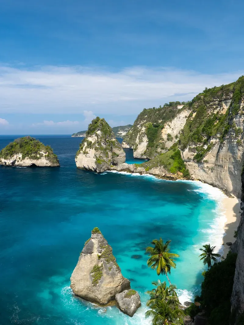
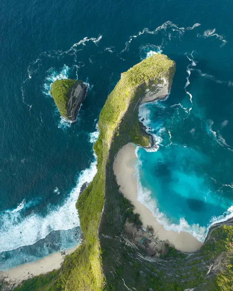
The southern coastline features sheer vertical drops. At Kelingking Beach, a narrow spine of rock extends into the ocean, resembling a Tyrannosaurus Rex. Visitors descend 400 meters of uneven, hand-carved limestone stairs to reach the white sand below. The path lacks continuous safety railings. Heat exhaustion and falls occur regularly on this cliff face, requiring emergency evacuations. The descent takes 45 minutes, while the climb back up often takes over an hour in the midday sun. On the eastern coast, Diamond Beach features a similar staircase carved directly into the white limestone cliffside. Visitors navigate narrow steps to reach a stretch of pristine white sand flanked by jagged rock formations. The ocean here generates a massive undertow. Swimming is strictly prohibited, as the currents have caused multiple drownings.
Ocean currents carve massive geological anomalies into the shoreline. Broken Beach, or Pasih Uug, consists of a collapsed cave roof that left behind a 200-meter-wide circular archway. Seawater rushes through the opening, filling a natural pool enclosed by 50-meter-high walls. Visitors walk along the limestone bridge spanning the arch, feeling the vibration of the waves crashing below. Nearby, Angel's Billabong forms a natural infinity pool in the volcanic rock. Swimmers enter the calm water during low tide to view the emerald-green algae growing on the bottom. High tide brings rogue waves that wash directly over the rock lip, pulling people out into the Badung Strait. Check local tide charts before approaching the water's edge.
Balinese Hinduism views Nusa Penida as the spiritual counterbalance to the main island. Mythology designates it as the home of Macaling, a powerful deity associated with disease and dark magic. Devotees travel across the Badung Strait to appease these forces, seeking balance between good and evil. Pilgrims arrive heavily laden with offerings, completing a circuit of the island's most potent temples to ward off sickness and misfortune.
Goa Giri Putri anchors this spiritual practice. The temple occupies a 300-meter-long limestone cave inside a mountain on the northeast coast. Worshippers enter by crawling through a narrow rock fissure just wide enough for one person. Inside, the cavern expands to a height of 15 meters, accommodating hundreds of people for ceremonies. The damp air smells of incense and echoes with the sound of chanting priests. Water drips from the stalactites, collecting in stone basins used for purification rituals.
Local village laws, known as Awig-Awig, govern environmental protection alongside religious duties. These traditional regulations established the island as a sanctuary for the critically endangered Bali Starling. The bird, recognized by its stark white plumage and striking blue skin around the eyes, thrives here thanks to the absence of natural predators and strict community enforcement. Poachers face severe social and financial penalties from the community, including banishment from village activities. Religious observance dictates daily life and visitor etiquette. Modest dress is strictly enforced at all sacred sites. Visitors attending any temple ceremony must wear a sarong and sash, covering their legs and waist entirely. These items are available for rent at the Goa Giri Putri entrance for IDR 10,000.
Goa Giri Putri requires visitors to crawl through a tiny rock fissure to access a 300-meter-long subterranean Hindu temple.
Dutch maps from the 1900s labeled the territory "Bandieten Eiland" because Balinese kings exiled criminals and dissidents here.
Cold upwellings between July and October bring massive Mola Mola to the shallow reefs to be cleaned by smaller fish.
A 20,057-hectare protected zone surrounds the island, requiring divers and snorkelers to pay a daily IDR 100,000 retribution fee.
Local regulations prohibit the sale of single-use plastics, including straws, bags, and water bottles under one liter.
Traditional village laws called Awig-Awig protect the island's bird populations, saving the endangered Bali Starling from extinction.
The public ferry from Padang Bai provides the only method to transport vehicles to the island, taking up to 90 minutes.
Fast boats depart daily from Sanur Port and Kusamba Port. The crossing from Sanur takes 30 to 45 minutes and costs between IDR 150,000 and 300,000.
Yes, an International Driving Permit with a motorcycle endorsement is legally required. Police issue fines up to IDR 1,000,000 for riding without the proper license.
No, ride-sharing applications do not operate on the island. Visitors must hire private drivers or rent scooters to navigate the roads.
Swimming at Kelingking Beach is highly dangerous due to massive waves and a powerful undertow. Multiple drownings occur here, and the beach lacks lifeguards.
The peak season for spotting the Oceanic Sunfish runs from July to October. Cold water upwellings during these months bring the fish up to shallower cleaning stations.
Approximately 10 to 15 ATMs operate in the northern villages of Toya Pakeh and Sampalan. They frequently run out of cash or reject foreign cards, making Indonesian Rupiah essential.
The Klungkung Regency Tourism Office charges an entry fee of IDR 25,000 per adult. Children pay a reduced rate of IDR 15,000.
Tap water on the island is not potable. Visitors must drink filtered or bottled water to prevent severe gastrointestinal illness.
Recreational drones under 2kg are permitted without a license. Flying over temples or large crowds is strictly prohibited by local authorities.
Most travelers stay for 1 to 3 days. Day trips from Bali are possible but require rushing between sites and dealing with peak afternoon crowds.
Browse verified tours with free cancellation and instant confirmation.
Find Tours